|
Maat-ka-Ra Hatshepsut |
last update: 03.01.2010 | |
|
Where was Punt ? |
![]()
| The question about the geographical location of the
mythical "God's country" of Punt (above the name in
hieroglyphics) has been a subject to scientific discussions for a long time
(see for example: Duke, R.; MDAIK 6, 1968; Fattovich, R., SAK supplement 4, 1991; El-Abbadi, M., bulletin de l'Institut d'Egypte, 1994, etc.), not only from
an egyptological point of view, but also from the view of the African
archaeology, because the region around the Red Sea formed probably the base for the principal trade ways between the Mediterranean area and India in
later, Greek and roman, times. For the old Egyptians, Punt was obviously an exotic country par excellence - full of wealthy things (see below), like the fabulous "Eldorado" in the 16. century (this comparison was made by Nathalie Beaux in a publication about "the curiosity cabinet of Thutmosis III", 1990). |
| After Fattovich (1996) different finds, e.g. Obsidian pieces of Ethiopian origin, suggest already predynastic, although probably no direct trade relations. There is some evidence for connections to Punt already during the Old Kingdom, but the descriptions of Punt in Egyptian sources are very rare from these times. Contacts with Punt are proven under the rule of the kings Sahura, Djedkara and Pepi II., 5. and 6. Dynasty, after el-Abbadi (1994) already for the 4. Dynasty under Khufu (Fattovich 1991). |
| The contacts with Punt during the reign of Sahura are mentioned on the Palermo stone. Based on the text 80000 units of Myrrh had been brought from Punt in his regnal year 12, however, whether Sahura had sent an expedition to Punt, is not clarified by the text. |
| This was recently confirmed by an inscribed limestone block discovered by an Egyptian team of the Supreme Council of Antiquities (SCA; Tarek el-Awadi) on the causeway of Sahura at Abusir. Text and pictures report about Sahura who is cultivating to potted myrrh trees brought from Punt. In the damaged text Sahura claimed that he was the first who brought the myrrh trees from Punt to be cultivated in his palace WTs-nfrw CAHw-Ra. |
| Other registers show 4 cargo ships bringing goods from an expedition. These ships belonged to the expedition the king had sent to Punt - what is illustrated by the goods being transported: people of Punt, characterized by their distinguished appearance, animals (dogs and apes) as wells as 3 trees which are identified as myrrh trees from Punt. |
|
Harkhuf, who lived in the 6. Dynasty under the reign of Pepi II, copied in
his grave in Aswan a letter from Pepi II in full wording, in which Pepi
II
said that he was very pleased that Harkhuf has brought along with him
a dwarf from the country JAm - a
dwarf who resembles another one that - approx.. 100 years ago - had
been brought to king Djedkara from Punt by a treasurer (of that king).
Thus, the country Punt is mentioned here as the country of the origin of this
dwarf.
Furthermore, the nobleman Pepi Nakht who lived under the reign of Pepi II. mentioned in his tomb in Elephantine that he had been responsible for the building of a ship for a travel to Punt. |
| The assumption that there already had been connections to Punt at the time of Khufu, was based on a representation in the grave of prince Seshat hotep, who was regarded to be a son of Khufu (Herzog, 1968). Lepsius, who opened his grave in winter 1842/43, described (quoted after Herzog, 1968) a servant or slave, who clearly distinguishable from other depicted people "by differences regarding belts and head-dress and recognizable by a brown-yellow color, definitely separated him from the red color of the surrounding Egyptians. He also carried a beard, while the other servants were beardless." Erman, who's argumentation was followed later by Breasted, interpreted the illustration 1885 as definitely showing a "Negro of Punt". In contrast, other interpreted the illustration as showing a Nubian! Since "Punt" was not mentioned anywhere in the corresponding text, this illustration is not generally accepted as a reference to Punt. Thus, for the first time Punt had obviously been mentioned on the Palermo stone. |
|
Expeditions after Punt occurred frequently in the middle and in the New Kingdom, the last one was done during the reign Ramses III (20. Dynasty, reported in Medinet Habu). During the New Kingdom numerous expeditions to Punt were done, e.g. during the reign of Thutmosis III, Amenhotep III, Haremhab, Sethi I and Ramses II (mentioned in his temple at Abydos). However, the most important description of Punt from the New Kingdom survived in the temple of Hatshepsut, Djeser djeseru, at Deir el-Bahari. Later, during the Persian rule over Egypt new expeditions to Punt were started again (as reported on a stele of Darius at Suez), but in Ptolemaic and roman times only "mythological" references existed to Punt (e.g. in a relief at Edfu, showing Ptolemaios XI, and in the temple of Isis at Philae, in connection with Ptolemaios VIII.). |
| Based on the Egyptian descriptions Punt was a tropical region, with palms and apes (see photo below), which could be reached both on an overland route and from the Red Sea coast. The discovery of a 12th Dynasty port at the Wadi Gawasîs north of Quseir (Sayed 1977, 1978) supports this, but gave no hints on the position of Punt. Sayed identified the place with the pharaonic port of sAww: there he found an inscribed stela of the vizier Antefoker (Middle Kingdom, reign of Senwosret II), which records that 3756 men were sent from this port for an expedition to Punt. |
| The area of Punt was obviously divided into several "regions", which extended over a wide area of the Red Sea coast and its backlands. According to Fattovich (1991) the inhabitants were apparently of afro-Mediterranean origin and bred a special race of cattle with short horns. These cattle suggest that the people from Punt had derived from the eastern area of the Sahara. In Egypt these short horn cattle appeared in the 5. Dynasty, however, they were not held frequently until the New Kingdom (Fattovich, 1991). The Punt houses - built on piles - are already described on a separate page. The ruler, a chieftain or priest king (of a snake God), accompanied by a lady of an obviously equal status, monitored the trade (with the Egyptians, s. Hall of Punt) apparently by himself - so at least with the expedition of the Hatshepsut. |
| Punt was located in the different areas, e.g. in: Syria, southern Arabia, eastern Sudan, northern Ethiopia, western Ethiopia, and Somalia
(see Herzog, 1968). For the localization even the appearance of the queen of Punt (Jti) and her daughter had been consulted and interpreted "medically". The appearance of both ladies at Djeser djeseru (today in Cairo, catalog NR. 34419) and on a sketch, now in the museum at Berlin (Ostracon, No. 21442) had led to the assumption that members of a Hottentots tribe or Bushmen had been illustrated here. Brunner-Traut (1974) rejects this, in her opinion the appearance resembles not on a Steatopygia but is the result of a pathological curvature of the spinal cord (Lordose). Beyond that obviously both ladies suffered from an extreme obesity (Adipositas). Due to Brunner there are no objections against the assumption that the illustrated people would not belong to an Ethiopic race. |
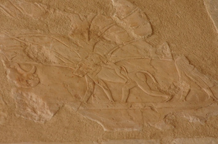
Above an old picture taken in the Hall of Punt, today it is hard to identify a fish at all (Nims, 1965). |
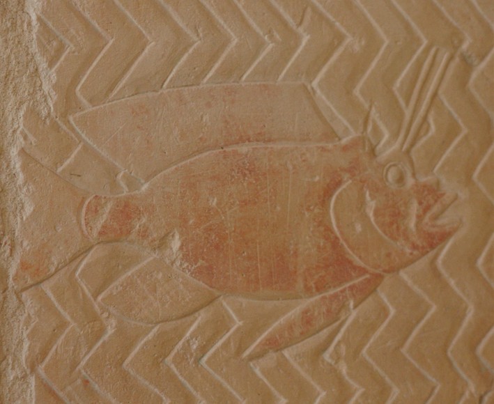
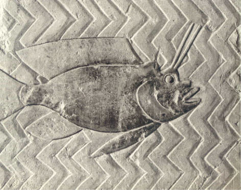
Above an actual photo of the fish shown on the left side (2006) |
| Danelius and Steinitz (1967) enriched the discussion by investigations of sea animals illustrated in the Hall of Punt and tried to localize the pictured fishes by a comparison with current marine fauna from the Red Sea. The material for the comparison with current animals had been supplied by an Israelian expedition, headed by the zoologist Steinitz. For the major time the group was stationed on an island approx.. 50 km far from the coast of Eritrea. Beside numerous other animal species more than 280 marine fishes - among them some new species - were collected and listed. |
| Since the relief of the Hall of Punt had been damaged to a large extent since their discovery, drawings from Naville's publication were used for comparison (below a part of the picture presented in Naville, E., "The Temple of Deir el-Bahari. Part III", photographed 1913). Photos were taken from the drawings and enlarged, then parts of the relief showing water and animals living therein were cut out. These pictures were examined by different experts on marine fishes. |
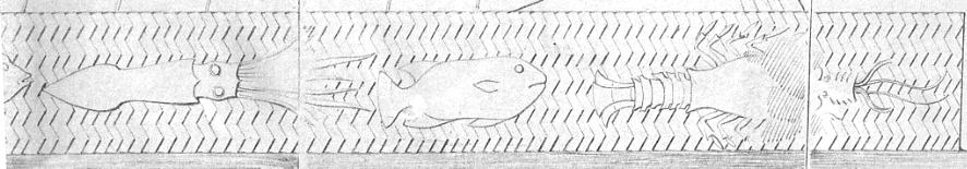
| The details shown above suggest the presence of
following species of families (according to: Sahrhage,
1998):
squid (Loligo), puffer or globe (Tetraodontidae), lobster (Panulirus) |
| Unfortunately the relief proved to be too inaccurate and
showed too few details, in order to determine individual species - only an allocation to certain families or groups
of marine fishes proved as feasible. However, it must be stated clearly that the relief in Deir el-Bahari did not show species from the Mediterranean Sea, but in contrast wholly tropical or subtropical species. Including some additionally pictured invertebrates (e.g. crayfish) this covers the marine fauna of the Indian ocean including the Red Sea and the Gulf region. |
| Hoffman (1973) discussed a note in pHarris I. (77, 9-10), from which it follows that
for the Egyptians of the 20. Dynasty the Red Sea was "flowing
in the opposite direction compared with the Nile". In her opinion this is to be explained only by the fact that the Egyptians had the winds in their
back while sailing to Punt . One actually knows a remarkable weather phenomenon, the Etesian. These occur very frequently from May to October and result in winds over Greece, the Greek Sea and the eastern part of the Mediterranean Sea with a north to northeastern direction. The Etesian are dry, relatively cool and partly stormy winds, especially on the open sea. They achieve in each case their largest strength in the early afternoon. The Etesian are closely related with the monsoon circulation over the Asia, i.e. one can regard them as a section branch of the monsoon circulation. On the Red Sea the Etesian produce a southern drift of the water down to the southern end of the Red Sea (gulf of Aden) - which then flows in the opposite direction to the river Nile! In the following months winds with a main direction from south to southeast drives the water to the north, but obviously only up to the area of Jeddah (on the Arab peninsula) or Tokar (on the African side) - in the northern part of the Red Sea northern winds remains dominant and therefore, also a southern water drift (the reason for this is most likely a transverse lowering in bottom of the Red Sea that goes from Jeddah to Tokar on the African side). |
| Hoffman concludes therefore that on their expeditions
to Punt the old Egyptians could not have sailed further to the south
than into the area of Tokar - otherwise they would have noticed the northern water
drift during winter, and the description that the Red Sea flows "in
the opposite direction" compared with the Nile, would have been
corrected. Interestingly this assumption corresponds well with the geo-archaeological map of the eastern area of the Sudan and the northern part of Ethiopia prepared by Fattovich (SAK supplement 4, 1991). This map shows that the coast between Port Sudan and Tokar is the ideal starting point for expeditions into inner Africa, because everything the Egyptians wanted to get in Punt is attainable from this coast. |
| Newer research tends therefore to a localize Punt
at the border Eritrea, Ethiopia and Sudan, between the blue Nile and the Red Sea, where everything (spices, gold, ebony) is to be found - also the landscape -, which was
depicted in the temple reliefs at Deir el-Bahari. The hypothesis is based on the following
facts:
- due to the Egyptian sources Punt is situated southeast from Egypt, near Wawat and Kush (= upper and lower Nubia). - incense and Myrrh trees are found in the area of Erkowit (in the mountains at Red Sea), in the flat western
area of Eritrea, in the Anseba valley, and on the plateau of Tigris; Ebony grows in the mountains
near the Red Sea, south of Port Sudan, and in the flat western area of Eritrea. - tales about a "mythical" snake king are still known in northern Ethiopia. - rock paintings showing short horn cattle were found southwest from Port Sudan, at the Ethiopian-Sudanese border, and in the Mareb/Gash valley. People with long hairs, who resemble those in the reliefs of Deir el-Bahari, were also represented in the area of May Aini. A geo-archaeological map of the eastern part of Sudan and northern part of Ethiopia (from Fattovich, R., SAK supplement 4, 1991) was placed on a separate page (because of the size of the figure). The map allows to find the numerous locations mentioned above. |
| The historical frequency of commercial contacts and also the
way how the Egyptians ha reached Punt indicate - as stated by Fattovich
- that it must be located on an area southeast from Nubia. A historical comparison of the
contacts lets assume therefore:
- that in the Old Kingdom the goods from Punt had been brought to Egypt on an overland route, whereby this was controlled by the people from Kerma; - that in the Middle Kingdom the sea route was preferred to travel to Punt, in order to evade the area of Kerma (however, this does not exclude additional contacts on an overland route); - that in the 2. intermediate period the trade with Punt was controlled by nomads of the eastern desert who for their part had contact with the Kerma culture; - that in the New Kingdom again ships were sent to Punt, until Nubia was fully controlled by Egypt; thereafter, the goods came also on an overland route, whereby the trade was controlled by nomads of the eastern desert; probably at the same time the trade with the west coast of the Arabian peninsula was started; - that the contact during the 20. Dynasty was stopped due to climatic changes and resulting political weakness of Egypt; - that thereafter until Ptolemaic times the trade with Punt and the southern areas of the Red Sea had been under control of people from Arabia, thus, Punt became a mythological idea. |
| As a further hint regarding the location of Punt may come from the tomb of Sobeknakht, governor at in Elkab during the 17th dynasty. Sobeknakht has constructed a tomb (No. 10) for himself which consisted of two halls. The tomb belongs to the rare tombs of the 17. Dynasty which were richly decorated. According to Porter& Moss (P& M V, Upper Egypt: Sites, P. 185) the walls of the outer hall as well as those of the entrances to the outer and inner hall had been decorated. Among other things the decoration on the west wall of the outer hall shows men who transport a mummy in a barque on a trolley - which is probably the oldest well-known representation of a vehicle with wheels in Egypt. |
| Recently in 2003 English and Egyptian conservators under the aegis of the British museum began to work at the tomb. During the restoration an inscription in the right thickness of the doorway between the inner and outer hall won special attention. The inscription attached horizontal in 22 lines with red characters, was not, as thought before due to the localization close to the tomb shaft a funerary, but a biographic-historical text (Davies, 2003; Davies, 2003). |
| The inscription described a ferocious invasion of Egypt by armies from the south " … Kush came…. having stirred up the tribes of Wawat … the land of Punt and the Medjaw. ". Furthermore, the text reports the successful counter attack under the direction of Sobeknakht who got help from vulture-goddess Nekhbet, patron-goddess of Elkab that finally expelled the aggressors. |
| Egyptologists had already known about repeated tensions between the Kingdom of Kush and Egypt but there was no evidence about a massive Invasion as reported be this text. |
| With regard to the localization of Punt the mention of allied powers "… from the land of Punt" is special interest. The inscription indicates that the land of Punt lay somewhere close to Kush. A localization of Punt on the Arab peninsula or south of Ethiopia, i.e. in the today's Somalia, appears therefore less probable. |
| All hints support a localization of Punt in the area at the border between Ethiopia and Sudan, but from a scientific point view this is still a hypothesis, which has to be proven by field research. Therefore, all ways to Punt are "open" again. |
|
Copyright: Dr. Karl H. Leser (Iufaa) |