|
The Chapel of Hathor - History of its Construction |
update:
29.08.2010
|
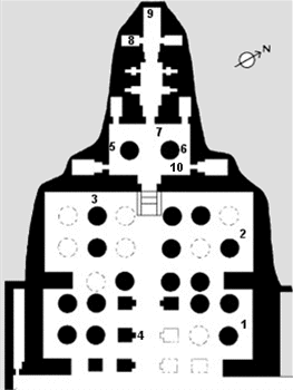
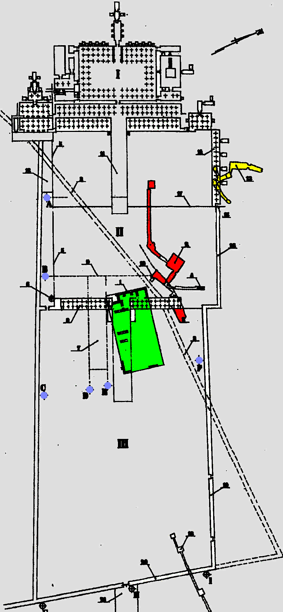
| Above the floor plan of the Chapel of Hathor with the location of various scenes.
|
| 1 |
Hathor-Cow inside a shrine;
opposite wall:
Hathor-Cow in a shrine is suckling and
protecting the royal child |
| 2 |
Procession of Hathor with barques and soldiers; in the
northwestern corner Thutmosis III is shown with an oar before Hathor |
| 3 |
from left to right, left (south) of the entrance:
ritual run with bird before Hathor,
Hathor-Cow licking the hands of the queen;
right (north) of the entrance:
Hathor-Cow licking the hands of the queen,
ritual run "Seizing the Oar".
|
| 4 |
Pillars with Hathor-standards, columns with Hathor-heads |
| 5 |
Weret-Hekau offering a menat to Amun |
| 6 |
Hatshepsut before Hathor |
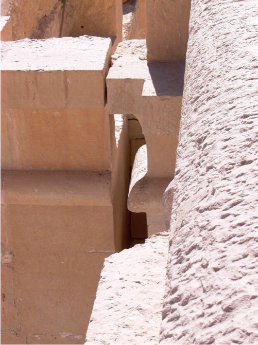
| 7 |
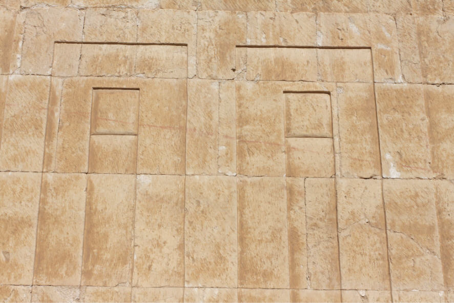
Royal titles on lintel and jambs, on both sides two Hathor-standards
(see photo below) |
| 8 |
Portraits of Senenmut |
| 9 |
Hatshepsut (replaced by Thutmosis III) embraced by Hathor,
both before Amun |
| 10 |
Hatshepsut (replaced by Thutmosis III) playing ball before Hathor |
|
|
According to Wysocki (1992) the purpose of the small room south of the
Chapel of Hathor is not known. |
| Development of the chapel |
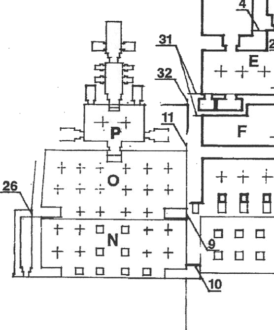
| According to Wysocki (1992) the construction of the chapel of
Hathor was started already during the first building phase under Thutmosis II.
He explained that by the fact that especially on the 3rd terrace and in the
Chapel of Hathor the name-rings of Hatshepsut had been replaced later by that of
her husband. |
 |
|
If one follows the argumentation of
Wysocki, then the work on the chapel already began during the construction of
the platform for the 3rd terrace. Additional evidence is provided by the
architectural findings of a connection between the southern retaining wall of
the 3rd terrace and the west wall of the 1st portico of the chapel (see left
part of a plan taken from Wysocki 1992, fig. 2, position 11). The connection is
visible the the back of the wall but not from the portico side.
Apparently, the work on the building was stopped - most likely when Thutmosis
II died - and restarted later by Hatshepsut. Wysocki (1992) explained that -
among other things - by the fact that at position 32 no connection had been
built between the retaining wall of the 3rd terrace and the west wall of the
chapel. |
| Wysocki assumed that the work on the temple had been started
again together with changes of plan Hatshepsut's accession to the the
throne - he summarized these work under building phase II. |
| The building phase under Hatshepsut has been also divided by
Wysocki into several sections. Beside work on the upper and 2nd terrace,
which must have been ready because the 2nd portico carries the columns of the
upper portico, Wysocki believes also that the work on the chapel of the Hathor
had been resumed in the 1st stage of the building phase II. Most likely, the
shrine which was begun under Thutmosis II (P in the above drawing) and the
pillared hall in front of it (O) might to have been accomplished. |
| According to Wysocki the 2nd stage in the time of Hatshepsut was
characterized by extending the temple northward, extending of the 2nd terrace to the East, and by the
construction of the southern retaining wall of the
2nd terrace. The 1st series of foundation deposits of the queen (marked by
Winlock A to F) encircled the new area. |
|
Wysocki (1992) assumed that during this phase the work on the Chapel of Hathor and its
1st pillared hall had been finished. In his opinion most probably also the 1st ramp
between southern retaining wall of the 2nd terrace and the northern
enclosure wall of the temple of Mentuhotep was finished - its slanting is marked
by the 1st
line at the southern retaining wall (see below) and its start west of the foundation
deposit A (which lay right on the line which still exists as a step on the
2nd terrace). This, however, means also that the western part of the retaining wall
must have been finished so far that it could support the ramp. |
|
The changes of plan for the 3rd terrace by the construction of the sun court induced also changes of plan for the 2nd
terrace. Since the use of the upper Chapel of Anubis was impaired by the
construction of the sun court, the northern wing of the 2nd portico was extended by
the construction of the lower Chapel of Anubis. |
|
The of the facade of the 2nd portico was already disturbed by the Chapel of
Hathor which was withdrawn westward, and this impression was increased by the
construction of the lower Chapel of Anubis, because this chapel was built in line
with the front of the 2nd portico. Therefore, facade was rebalanced by the
building of a 2nd pillared hall (N in the plan above) in front of the Chapel of
Hathor. |
|
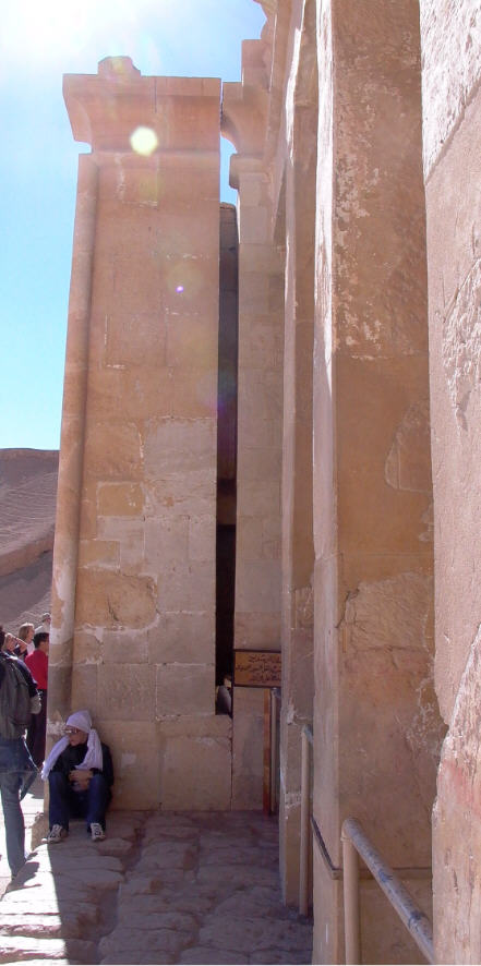
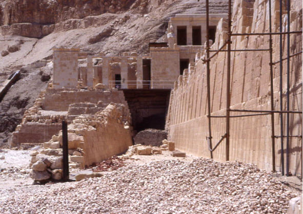
Front of the 2nd pillared hall of the Chapel of Hathor, which was partly built
over of the southern wing of the 2nd portico. One clearly recognizes the gap
between the two buildings and the already finished execution of a torus moulding
and cavetto cornice at the wall of the southern wing. |
| That the 2nd pillared hall was added later is demonstrated by
the observation that it has no bonding with the southern wall of the 2nd portico
(see photos above). The photos above show clearly that the facade of portico of
the Chapel of Hathor lies in front (and overlapping) the portico of the 2nd
terrace.
|
| The addition of the 2nd pillared hall in front of the Chapel of Hathor
required a modification, i.e. an eastward shift of the ramp which led to the
chapel (see below). |
| The Chapel of Hathor was accessible by an own ramp which
covered a difference in altitude between the chapel and the level of the 1st
court by about 9 ms. On its north side the ramp lent against the southern retaining wall of the 2nd terrace and
on its southern side against the old
limestone enclosure wall of the temple of Mentuhotep Nebhepetra. The layers of the old limestone wall built by Mentuhotep have been
preserved up to a height of about 2.20 ms, this was was raised under Hatshepsut to support the ramp.
The southern retaining wall of the ramp to the Chapel of Hathor does
not run parallel to the retaining wall of the main temple - from the head of the
ramp at the Chapel of Hathor down to the the edge of 1st. portico the width
increases by about 2 ms. |
| How the original access to the Chapel of Hathor was planned, is
hard to reconstruct. Clarke (in: Naville, E., The Temple of Deir el-Bahari,
part VI London 1894-1908, p. 22) suggested that in the 1st stage of development
of the chapel access from the 2nd terrace may have been possible over a narrow
ledge. However, he thought that such a method of approach was deemed "ignominious"
and "unserviceable" and therefore out of question. |
| So Clarke was forced to suppose that at the beginning a system
of stairs or an inclined plane ascended from the lower level to the chapel. |
| During the excavation Naville and Clarke discovered 6 slant lines marked
with red paint on the
southern retaining wall of the 2nd terrace (see the following illustration). Somers
Clarke, the architect working with Naville, concluded that the furthest westward
and the furthest eastward line indicated the slope of the first and the finally
erected 2nd ramp to the chapel - all other lines between the extreme west and
east line were regarded by Somers Clarke as experimental lines (according to
Wysocki, 1985a). |
| Furthermore, Clarke concluded that the ramp did not
cover the entire space between the retaining wall of the 2nd terrace and the
enclosure wall the Mentuhotep district, but only adjoined the retaining
wall of the 2nd terrace (see Naville, E., loc. cit., plate CLXXIV). IHis
conclusion was based on the evidence of weathering at both walls and and
rough tooling of the stones of the retaining wall of the terrace, where they
were covered by the ramp. |
| Wysocki (1985a) contradicted the assumption that the ramp
did not cover the entire space between the retaining wall of the 2nd terrace and
the enclosure wall of the Mentuhotep district. In his view the weathering
observed on the enclosure wall was not relevant since the wall was exposed to
the weather already for several centuries. |

| Detail taken from: Naville, E., The Temple of Deir el-Bahari,
part VI London 1894-1908, plate CLXXI. The picture shows on the left the 2nd
pillared hall of the chapel and to the right the remains of the retaining wall
of the 2nd terrace. |
| At the southern, exterior retaining wall Naville and Clarke had
identified 6 lines, which indicate the slope of different ramps leading to
chapel. Thereby, the two western (red) lines most likely mark the slope of two
ramps which may have led to the chapel, before the chapel had been extended eastward by the
2nd pillared hall. Due to this figure the 2nd ramp had started slightly east of the foundation deposit A,
resp., right on the line which still exists as a step (red arrow and photo below) on the 2nd
terrace. |
| The more eastern (green) lines show most likely the slope of
those ramps which were built after the 2nd terrace had been extended
eastwards.
|
| Based on the plan above the following rough estimations
are possible - if one takes the eastern side of the 2nd pillared hall as the
point of reference, then the 1st ramp started approximately 27 ms and the last
ramp 58 ms further east, whereby the distance between the eastern side of the
2nd pillared hall and the eastern side of the 1st portico is approx. 85 ms.
Taking into calculation the difference in altitude of approx. 9 ms the
gradient of the furthest westward line is approx. 33% and about 15% for the
furthest eastward line. |
| In the plan CLXXI, shown above, one recognizes
immediately that all lines - with exception of the westernmost - partly cross
the decoration of the southern retaining wall of the 2nd terrace. That means
that each ramp, which had followed one these lines, which would have covered
parts of the decoration of the retaining wall. |
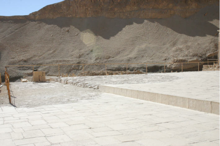
| Step on the 2nd terrace which corresponds with the 2nd line in
the drawing from Naville. |
|
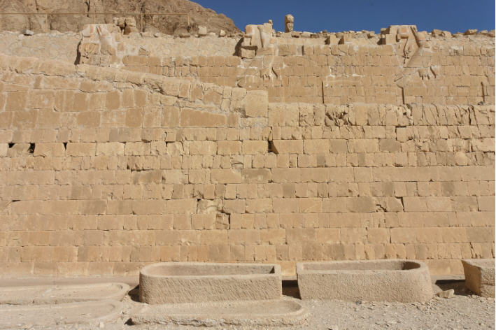
On the left the remains of the southern retaining wall of the ramp which had led to the Chapel of Hathor; on the right side the photo shows the retaining wall of the
2nd terrace. The southern (left) retaining wall was built over the remains of an
enclosure wall of the temple of Mentuhotep. Straight
forward, between the retaining wall of the ramp and the retaining wall of the
2nd terrace
there are the remains of another mud-brick enclosure wall of the Mentuhotep-district.
This mud-brick wall was covered by the ramp to the Chapel of Hathor and the 2nd
terrace. |
| Wysocki (1985a, 1985b) reported that his team was only able to find
again all lines (1985a, plate 5; 1985b, Fig. 1). He also agreed that the lines indicated the
slope of ramps. However, in contrast to Clarke he was convinced that
several ramps had been built subsequently to adopt the ramp to the
eastward extension of the temple. |
| In the 2nd publication (1985b) Wysocki discussed in detail
the lines on the southern retaining wall of the 2nd terrace. However, both
publications from 1985 are not consistent, in report 1985a he wrote that they
found again 4 lines, in 1985b they had found 5 lines. Also the slant of the
lines is differently presented in both publications (1985a, plate 5; 1985b, Fig.
2). |
| In the 2nd publication Wysocki had drawn the following
conclusions: |
| - most likely, the ramp leading to the Chapel of Hathor was
carried out totally in 4 succeeding versions, each of them decreasing its
inclination and increasing its length; however, at least the 1st and 4th version
which are associated with lines 1 and 5 were carried out (see I in figure
below); |
| - the 1st ramp was built before the Chapel of Hathor (by the
2nd pillared hall) and the 2nd terrace were extended to the east; |
| - the 2nd line from the west (which was visible in the days of
Naville and Clarke but not anymore in the days of Wysocki) is to be considered
as experimental; |
| - a 2nd version of the ramp (indicated by the 3rd from the west)
was raised after the extension of the Chapel of Hathor and the 2nd terrace to
the east; the 2nd experimental line may reflect a correction of the inclination
of a part of the 2nd ramp (see II in figure below); |
| - perhaps a 3rd version (indicated by the 4th line from the
west) was raised associated with another extension of the 2nd terrace to the
east (see III in figure below); |
| - the 4th and final version of the ramp (indicated by the eth
line from the west) was probably raised after the portico of the 1st terrace was
completed (IV in figure below); |
| - Wysocki reconstructed the final version - and already the 3rd
version - with a theoretical landing so that the course of the ramp did
interfere with the decoration of the southern retaining wall of the 2nd.
terrace; |
| - finally Wysocki concluded that the ramp had a flight of
stairs in its middle part like all the other ramps leading up to the terraces of
the temple. |
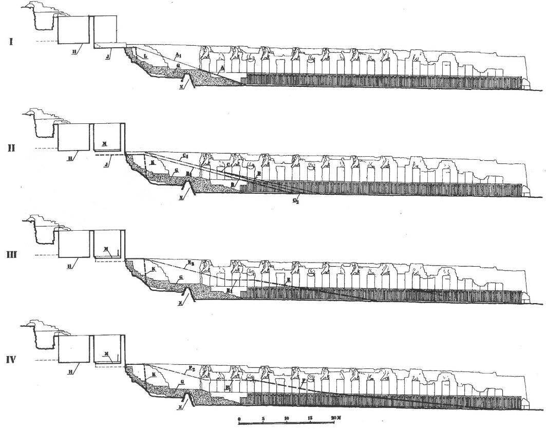
| Theoretical slope of the 4 ramps which - most likely -had been
erected according to Wysocki (taken from: Wysocki 1985b). |
| As mentioned above, in consequence of reconstruction and extension of the ramp the
enclosure wall of Mentuhotep was raised (see photo below) so that it could
support the southern side of the ramp and function also as balustrade. |
| Southern retaining wall of the ramp to the Chapel of Hathor - the
lower rows of smaller belong to the enclosure wall of the temple of Mentuhotep II,
the upper rows with larger blocks belong to Hatshepsut. |
| If one gets access to the area the red lines mentioned by
Naville and Wysocki are still partly visible. |
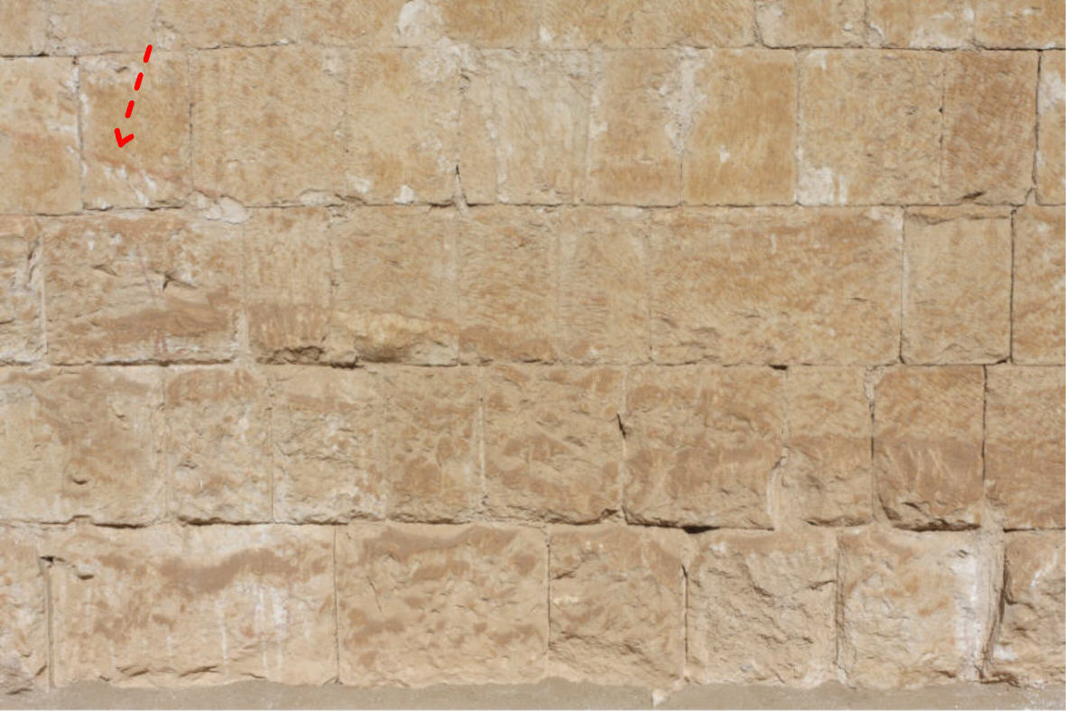
| The photo above shows the beginning of the 1st re line (see
arrow). It is obvious that the stones below the line were roughly hewn,
whereas the blocks above were carefully smoothed. |
| The photo shows that one of the red lines runs directly
through the palace-facade decoration, indicating that the corresponding ramp had
been planned after the decoration of the southern retaining wall of the 2nd
terrace had been finished. |
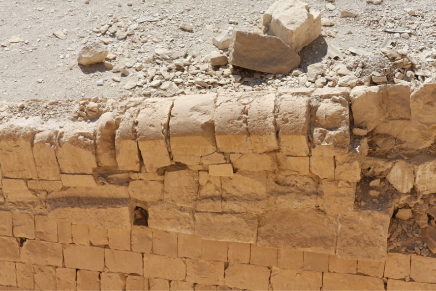
| This photo shows the northern side of the southern supporting
wall of the ramp to the Chapel of Hathor. It shows the beginning of the stone
blocks placed by Hatshepsut on the top of the wall of Mentuhotep. The lower
blocks of Hatshepsut show a slanting upper border suggesting that these stone
were part of the ramp. |
| Neither Naville nor Wysocki have published data about the
design of the platform in front of the chapel. However, based on the
publications of both authors and the scales given in the corresponding plates it
is possible to estimate that
- based on Navilles plan the last right (easternmost) painted line reached
the level of the central terrace approx. 8 m before the portico of the chapel -
thus, if this line shows the slant of the final ramp, then the platform in front
of the chapel was approx. 8 m deep, and
- based on Wysocki (1985b) the last right (easternmost) line (= ramp) reached
the platform about 3.3 m in front of the chapel. |
|